Features:
Outwash Plain
Kames
Kame Delta
Drumlin
Erratic
Kettle
Stream features:
Floodplain
Levee
Point Bar
Cut Bank
Meanders
Meander Cutoffs
Ox-Bow Lakes
Outwash Plain
The area beyond the terminus of the glacier, where melt water can carry glacial sediments, is called the outwash plain. Features formed in this region beyond the glacier tend to be made of stratified (sorted) small sediments. In general, any feature where liquid water is involved tends to be well sorted in terms of the type of material that comprises it. Areas that do not have flowing water tend to have unstratified (poorly sorted) sediments making them up (Richardson, Tarbuck and Lutgens).
Kames
Kames are conical hills formed by uneven heating on the top of the glacier. They are composed of unstratified sediments, because there is no meltwater involved. Because of the lack of flowing water, the grains do not get sorted out due to size, but rather stay all mixed up. The formation of a kame goes as follows: 1. Uneven heating on the top of the glacier causes depressions to melt in the top. 2. The depression gets filled in by sediments falling on top of the glacier. 3. The glacier melts, leaving a conical pile of sediment called a kame (Richardson, Tarbuck and Lutgens).

(Image drawn by Alex Gough)
Kame Delta
A kame delta is a triangular depositional feature formed when a glacier is retreating. Sediments flow in streams of meltwater towards the terminus (end) of the glacier. These sediments are then deposited in stratified (sorted) layers, forming a delta, similar to those found at the end of a river on land. The sediments here are stratified because of the meltwater involved in their transportation. The ice later retreats, and this sediment is brought down to ground level, in the same way that a regular kame forms. (Allaby)

Drumlins
Drumlins are asymmetrical hills composed of unsorted sediments deposited by glaciers during their retreat. The exact way that drumlins are formed is disputed among glaciologists, however it is known that the steep side of the drumlin points to where the glacier came from, and the gently sloping side points to where the glacier was heading. (Richardson, Tarbuck and Lutgens)


Erratic
Erratics are rocks that were plucked up by a glacier, and when the glacier melted, deposited in a new area. Identifying rocks as erratics is a fairly easy task, as they will often be rocks sitting on a pile of soft sediment, or a rock sitting on a bedrock with a completely different composition. Erratics can range in size from small fist sized chunks to ones the size of small houses! (Richardson)
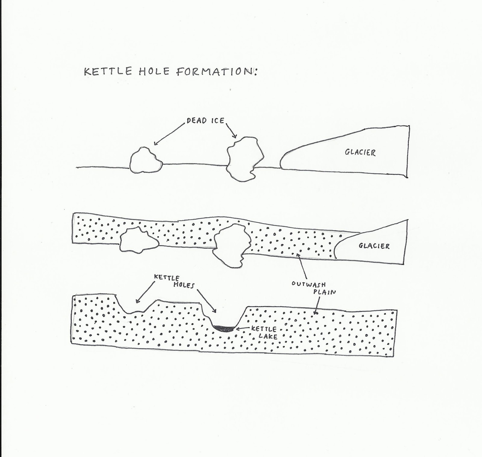
Kettles
Kettle holes are depressions in the ground caused by ice breaking off the glacier onto the ground as it is retreating. This block of ice then gets covered by sediments that get dumped on it by the glacier. As the ice melts, a depression is left behind, which sometimes fills with water, forming a kettle pond, or vernal pool (Richardson, Tarbuck and Lutgens).
Stream Features

Floodplain
The floodplain of a river is the flat area around a river that, when the river floods, gets water from the river. This area tends to be composed of fertile mud and clay, where marsh plants and swamps can form. They also tend to be well sorted in terms of the sediment that makes them up because of the liquid water that is involved in their creation. Older rivers tend to have wider floodplains than younger rivers (Richardson,Tarbuck and Lutgens).
Levees
Natural levees form when a river overflows its banks, causing coarse sediment to build up in ridges that run parallel to the river. Smaller sediments carried in the water column such as mud and clay get washed into the floodplain (Richardson, Tarbuck and Lutgens).
Point Bars
Point bars are located on the insides of bends on rivers. Because the water has to be squeezed around a tighter turn, the water slows down. As it does so, the water deposits its sediments here (Richardson, Tarbuck and Lutgens).
Cut Banks
Cut banks are located on the outside of bends in rivers. Here, because the water has a large amount of space to make its turn, the water can maintain its fast speed. As a result of this, cut banks experience high erosion (Richardson, Tarbuck and Lutgens).
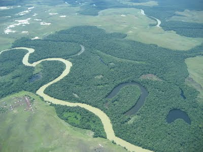
Meanders
Meanders are curves in a river created by the difference in stream velocity on the insides of the bends (point bars) and the outsides of the bends (cut banks). Because the water at point bars has to make tighter turns than the water at cut banks, the water at point bars slows down. When water slows, it can no longer hold the sediments it was carrying. As a result of this the river's cross section becomes asymmetrical. Over time, as sediments get deposited in the shallow areas, point bars, and get eroded in the deeper areas, cut banks, these meanders become more exaggerated over time. So, if a river has many meanders and exaggerated curves, it is said to be an old river, if it is fairly straight then it is said to be a young river (Richardson, Tarbuck and Lutgens).

Meander Cutoffs
When a meander becomes very curvy some water may overflow the curve to form a straighter path. In doing so, a secondary channel for the water to flow in is created. This is called a meander cutoff (Richardson, Tarbuck and Lutgens).

Ox-Bow Lakes
An oxbow lake forms when a meander cutoff becomes the prefered channel for the water to take down the river. When this happens, the water slows at the entrance and exit of the meander, depositing sediments. This cuts off the meander, forming a banana shaped lake, which may or may not dry up. The formation of oxbow lakes is a sign that a river is fairly old, as very exaggerated meanders are needed for these to form (Richardson, Tarbuck and Lutgens).