The shape of the land in the Northeast region of the United States has been
greatly influenced by the activities of glaciers and ice sheets in the
past 20,000 to 15,000 years. Most of the glacial shaping to occur
in the Northeast of the United States was a result of the last ice
age. During this period, an ice sheet called the Laurentide Ice
Sheet or the Wisconsinan Ice Sheet covered major portions of the
Northern United States and almost all of Canada (Raymo and Raymo). Before we
discuss the features caused by this ice sheet, let's do a quick recap
on what glaciers are and what they do.
What is a glacier?
A glacier is a mass of ice that currently has a
fluid motion to it, or exhibits evidence of past flow. They form during
periods of high snowfall. The snow, if it does not melt, piles up on
itself, and this, over time, builds up a high pressure. As the
pressure increases, the air between snow particles is squished out,
causing the snow to crystalize into ice. Under enough pressure,
this ice can flow as if it were a very viscous liquid. Scientists
call this type of motion "internal plastic flow" (Richardson, Tarbuck
and Lutgens).
What is an ice sheet?
Ice sheets (also called continental glaciers) are
simply glaciers that cover the majority of a land mass. Unlike
valley glaciers, also called alpine glaciers, which are relatively
small and form in the mountains, ice sheets cover large areas of land
and tend to flow out from one or multiple centers (Tarbuck and Lutgens).
How do Ice Sheets and Valley
Glaciers Differ?
| Ice Sheets |
Valley Glaciers |
| Cover large portions of land |
Are relatively small |
| Spread in all directions from
center(s) |
Flow in one direction, like a
river |
| Tend to flatten landscape |
Tend to carve the landscape into
u-shaped valleys |
| Only two left today, the
Antarctic Ice Sheet and the Greenland Ice Sheet |
Are many left today |
The budget of a glacier
The budget of a glacier describes whether it is making forward progress, retreating or staying in the same place. If the glacier has a positive budget then the glacier advances, if the budget is negative the glacier retreats. It is important to note that glaciers move because of the force of gravity, and so, always move downhill. When a glacier is retreating, the ice does not flow uphill, rather, the end of the glacier melts faster than the ice/snow coming in to replace it (Richardson, Tarbuck and Lutgens).
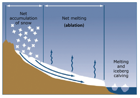
The snow line is the imaginary line that marks where the annual amount of snow that falls is equal to the amount of snow that melts each year. The area above this line is called the zone of accumulation. In this area, the amount of snow that falls exceeds the amount of snow that melts each year. The area below the snow line is called the zone of ablation, and marks where more snow melts than falls each year. Using the relative motion of the snow line in relation to the zone of accumulation and ablation, scientists are able to calculate if a glacier is advancing or retreating. If the snow line falls, that is, cuts into the zone of ablation more, the zone of accumulation increases in size. This means that the net gain of snow each year for the glacier will rise, causing the glacier to advance. Conversely, if the snow line rises, and cuts into the zone of accumulation, the glacier will have more melting than snow fall and the glacier will retreat (Richardson, Tarbuck and Lutgens).
What was the Laurentide Ice Sheet?
The Laurentide Ice Sheet was the major force responsible for shaping most of the Northeast of the United States and Canada. This was a major ice sheet in the area during the Pleistocene Era, which lasted from about 2.4 million years ago to 11,000 years ago.

During this period global temperatures were low enough to form large continental ice sheets all over the world in an ice age (Raymo and Raymo). The greatest amount of accumulation for the Laurentide Ice Sheet was near current day Hudson Bay, Canada, where the snow reached over 2 miles thick! (United States Geological Survey). About 21,000 years ago, the Laurentide Ice Sheet reached its maximum extent, reaching as far south as Chicago and New York (Ansley). At this point in time, sea levels were about 400 feet lower than their current day levels, as all the water was being frozen into these huge ice sheets (United States Geological Survey). About 2,000 years after that point in time, or about 19,000 years ago, global temperatures began to rise, and the ice sheets began to retreat. The Laurentide ice sheet retreated from this region somewhere between 14,000 and 15,000 years ago (Daukas, United States Geological Survey).

How do glaciers change our landscape?
Glaciers can affect geological topography in two ways, erosion and deposition (Richardson).
Erosion
Erosion is closely related to weathering, which is the breaking down of solids due to environmental factors such as wind, water or chemical exposure. Weathering slowly breaks rocks apart into gradually smaller pieces, which may appear similar to the parent rock, or may have been changed chemically in the weathering process. For more information on weathering, see below. Erosion is the transportation of these weathered sediments to new locations. Common agents of erosion include, rivers, the wind and glaciers. Glaciers move these sediments in two ways, plucking and abrasion (Richardson, Tarbuck and Lutgens).
Abrasion is sort of a combination of weathering and erosion at once. Simply put, abrasion is the rubbing of two things together to grind them into smaller pieces. In doing so there must be motion involved, and some of the sediment created here gets dragged along in the direction of motion (Richardson).
Plucking is when an object freezes onto the bottom of the glacier, and is dragged to another location where the ice melts and the object is dropped. The pieces picked up can be small pieces of sand and gravel or they can be the size of large boulders. The pieces along the bottom of the glacier can rub along the ground, causing the ground to erode, carving the landscape (Richardson, Tarbuck and Lutgens).
The Massachusetts area does not have huge amounts of erosional features, as many of them are only associated with alpine glaciers and this region was mostly carved by continental ice sheets.
Here is a list of common erosional features:
-Striations- Scratches caused by plucked objects rubbing along the rock
-U-shaped Valleys- Associated with alpine glaciers
-Cirques- Also associated with alpine glaciers, a bowl shaped dent in a mountain carved at the source of a glacier
-Tarn- A lake that forms in bedrock, usually in a cirque
-Arete- When two cirques or u-shaped valleys come together to form a thin ridge between them
-Horn- When three cirques surround a point and carve out a very steep and pointed summit
-Roche Mountennee- An asymmetrical feature made of bedrock, the shallow side having undergone abrasion and the steeper side having undergone plucking. The steep side points in the direction of the motion of the glacier (Richardson, Tarbuck and Lutgens).

Deposition
Depositional features are ones that form as the ice drops the sediment it has been carrying. These form when the ice is melting, and so are associated with the retreat of a glacier. Some depositional features are only associated with the snout of a glacier and, can mark the extent of its reach. Many features in the Massachusetts area are some sort of depositional feature that formed during the retreat of the Laurentide ice sheet around 15,000 years ago.
For more specifics on the types of depositional features in the area, please look at our Take a Tour section.
Weathering Processes
There are two categories of weathering, mechanical, where the parent rock is simply broken into smaller pieces, and chemical, where the outside layer of the rock is changed chemically by certain factors (Richardson, Tarbuck and Lutgens).
Some mechanical processes include:
-Ice/frost wedging- As water seeps into cracks in rocks and freezes, it expands, slowly breaking the rock apart
-Root wedging- When plant roots get into cracks in rocks, slowly forcing the rock to break
-Abrasion- The rubbing of one object against a rock, slowly wearing down its surface due to friction (See also the erosion section) (Richardson, Tarbuck and Lutgens).
Some chemical processes include:
-Hydrolysis- When minerals in the rock react with water, changing chemical composition. An example of this is feldspar (a mineral found in granite) changing into kaolinite (a type of clay).
-Oxidation- When minerals in the rock react with the oxygen in the air to form new compounds. The most common example of this is iron turning into iron oxide (rust).
-Organic Acids- Certain plants, mainly mosses and lichens, can release acids onto the surface of rocks, which eat away at their surfaces (Richardson, Tarbuck and Lutgens).